The Best Fishing Apps Every Angler Should Use
Skip the fluff. These five apps actually improve your catch rate and trip planning.
By Alain Quiroga · December 14, 2025 · 5 min read
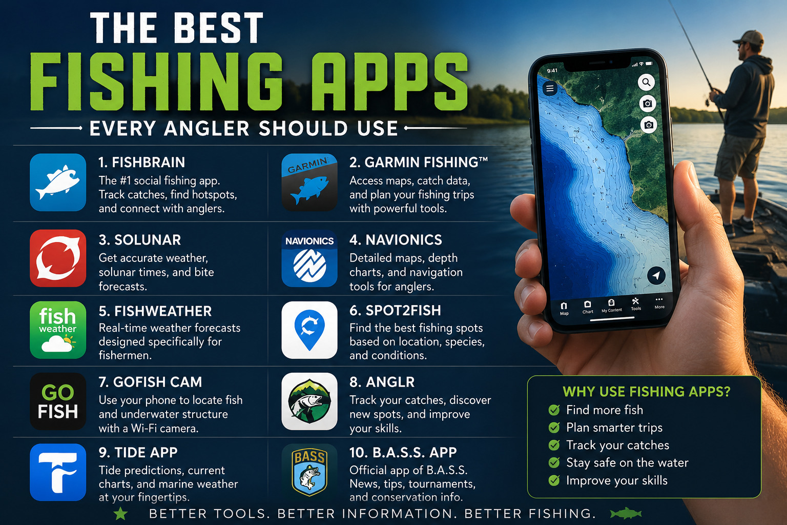
Modern angling has evolved beyond simple intuition, with digital tools now providing a significant edge on the water. Today’s best fishing apps offer everything from high-resolution bathymetric charts to real-time solunar data, allowing fishermen to transition from guesswork to data-driven strategy. Whether you are targeting elusive smallmouth bass in the rocky shoals of Lake Erie or scouting for redfish in the expansive salt marshes of Louisiana, leveraging the right mobile software can drastically increase your hook-up ratio and ensure safety in unpredictable conditions.
Precision Navigation and Bathymetry with Navionics
When it comes to navigating complex underwater terrain, Navionics Boating remains the gold standard for serious anglers. This app provides incredibly detailed contour maps that reveal hidden structures such as submerged creek beds, rock piles, and steep drop-offs that often hold trophy fish. For instance, on a massive reservoir like Lake Texoma, identifying a 20-foot ledge near a primary point can be the difference between a limit of striped bass and an empty livewell. The app’s SonarChart feature allows for 1-foot contour intervals, giving you a distinct advantage when trying to locate specific thermoclines or hard-bottom transitions favored by walleye or bottom-dwelling catfish.
Beyond simple depth readings, Navionics allows users to contribute to local data through community edits. This is particularly useful in dynamic environments like the Mississippi River delta, where siltation and shifting currents constantly alter the underwater landscape. By utilizing the app’s satellite overlay and shading features, you can visualize the transition from shallow grass flats to deep-water channels. This level of detail helps in choosing the right gear, such as opting for a deep-diving crankbait on a 15-foot shelf versus a topwater lure in the shallows during the early morning feeding frenzy.
Social Scouting and Catch Tracking with Fishbrain
Fishbrain has revolutionized the way anglers share information and track their personal progress. With over 15 million users, it serves as a massive database of real-world catch data across the United States. Anglers can see exactly what species have been caught in specific locations, like the heavy-hitting largemouth bass of Lake Fork, Texas. The app tracks the lures used, the time of day, and even the weather conditions at the moment of the catch. This data allows you to identify patterns; for example, seeing a surge in catches on a Zara Spook during an overcast morning might prompt you to switch your tactics immediately.
The utility of Fishbrain extends to its predictive modeling, which suggests the best times to fish based on historical data and current forecast trends. If you are planning a trip to the Kennebec River for striped bass, the app can suggest the most effective fly patterns or soft plastics based on what local experts are currently finding successful. It also functions as a digital tackle box, allowing you to log your gear and see which specific setups, such as a 7-foot medium-heavy baitcasting rod or 12-pound fluorocarbon line, are yielding the best results in your local pond or favorite state park lake.
Timing the Bite with Solunar Theory Apps
Success on the water is often dictated by the lunar cycle, and the Fishing & Hunting Solunar Time app is a premier tool for timing your outings. This app calculates the major and minor feeding periods based on the moon's position relative to your specific coordinates. For those targeting muskellunge in the Northwoods of Wisconsin or the massive blue catfish of the James River, hitting these windows is critical. During a 'major' window, predatory fish are often more aggressive, making them more likely to strike a larger bait like a double-bladed bucktail or a live gizzard shad.
The solunar theory suggests that the gravitational pull of the moon influences fish activity levels, similar to how it dictates ocean tides. While it is not a foolproof guarantee of a bite, many professional tournament anglers use these windows to prioritize their highest-percentage spots. If a major window coincides with a sunrise or a falling barometer, the chances of a trophy catch increase exponentially. By checking these times before you launch at the boat ramp, you can better manage your energy and focus, ensuring your lures are in the water during the most productive minutes of the day.
Analyzing Atmospheric Conditions with FishWeather
Weather is perhaps the most significant variable in fishing, and FishWeather provides the granular data necessary for a safe and successful trip. Unlike standard weather apps, FishWeather utilizes a network of over 50,000 weather stations, many of which are located directly on piers, buoys, and coastal points. For an angler crossing the vast stretches of the Albemarle Sound or navigating the open waters of Lake Michigan, knowing the exact wind speed and direction is paramount. A sudden shift to an offshore wind can flatten the surf for beach anglers but create treacherous "washing machine" conditions for small boaters in deep water.
The app also tracks barometric pressure, which is a vital indicator for freshwater species. Many seasoned pros believe that a falling barometer ahead of a cold front triggers a feeding binge among black crappie and northern pike. FishWeather allows you to monitor these pressure changes in real-time. Additionally, its sea surface temperature (SST) maps are essential for offshore anglers. Locating a sharp temperature break in the Gulf Stream can lead you directly to mahi-mahi or yellowfin tuna, as these species follow temperature gradients to find baitfish like ballyhoo and flying fish.
Compliance and Navigation Logistics
Safe navigation and legal compliance are often overlooked aspects of the angling experience, but apps like ANGLR and various state-specific fish and wildlife apps are filling that gap. ANGLR acts as a comprehensive trip logger that runs in the background, recording your route, waypoints, and every cast if synced with compatible gear. This creates a "breadcrumb trail" that is invaluable when navigating back through the tangled mangroves of the Everglades or the winding timber-choked arms of Truman Lake. Knowing exactly how you moved through a complex environment allows you to replicate successful patterns on future trips.
Furthermore, many states now offer dedicated apps that provide instant access to fishing regulations and license renewals. In a destination like the Bighorn River in Montana or the trout streams of Pennsylvania, regulations regarding bag limits, size restrictions, and tackle requirements (such as barbless hooks) can change from one section of water to the next. Having a digital copy of the most recent handbook and a GPS-linked map of restricted zones ensures you remain compliant with local conservation laws. These tools protect both the angler from hefty fines and the aquatic ecosystems from overharvesting, preserving the sport for future generations.
Frequently asked questions
What is the best fishing app for social networking?
Fishbrain is the leading social platform for anglers, allowing users to log catches and view real-time data from other fishermen. It provides detailed maps and indicates which lures, such as a Rapala original floater or a Strike King crankbait, are currently producing results in specific water bodies like Lake Okeechobee or the St. Lawrence River.
Which fishing app offers the best bathymetric maps?
Navionics is the industry standard for depth charts and underwater structure. It offers high-definition mapping that helps anglers identify drop-offs, submerged points, and brush piles where species like largemouth bass or walleye congregate. The app is essential for safe navigation through rocky hazards in systems like the Boundary Waters or the Florida Keys.
How do fishing apps help with weather safety?
The FishWeather app provides highly localized wind forecasts, which are critical for safety and positioning. Knowing the difference between a 5 mph breeze and a 15 mph gust is vital when fishing open water like the Great Lakes or the Chesapeake Bay, as wind direction influences baitfish movement and surface temperatures.
Are solunar fishing apps scientifically accurate?
Solunar apps use the positions of the moon and sun to predict peak activity periods. While not a guarantee, many anglers find that major and minor feeding windows often align with these celestial phases. This can be especially useful when targeting trophy muskellunge or nocturnal species like channel catfish during specific lunar cycles.
Related articles
Best Fishing Rod and Reel Combos for Beginners
The right first rod accelerates the learning curve. These combos balance price, durability, and performance.
Alain Quiroga · Feb 22, 2026 · 5 min read
Top Fishing Gear Under $100
Premium performance, budget price. These picks deliver outsized value on the water.
Alain Quiroga · Nov 2, 2025 · 5 min read
Best Artificial Baits for Freshwater Fishing
These artificial baits produce in nearly any U.S. freshwater situation — without the mess of live bait.
Alain Quiroga · Oct 26, 2025 · 5 min read